Official tourism website for Northern Ireland
En

Beaghmore Stone Circles

Blackrock Road, Cookstown, County Tyrone, BT80 9PB
Image of the Beaghmore stone circle with the sun setting in the distance

Book Tickets Online

About

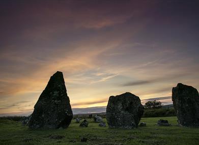
Nestled amongst the green grass and heather clad moorland sit 7 mystical circles, 10 rows of stones and 12 cairns, carefully arranged.

Beaghmore (Bheitheach Mhór), meaning ‘big place of birch trees’ was once a dense woodland before being cleared by Neolithic farmers. The circles and alignments were discovered in the late 1930s during peat cutting when 1,269 stones were uncovered. The site and the surrounding bog indicate that the area was occupied from Neolithic times through the Bronze Age.  Hearths and deposits of flint tools have been carbon dated to 2900-2600BC. Several of the stone rows run over the tumbled walls of field structures which also date from Neolithic times.

Look closely at some of the stones and what may seem as ancient chisel marks bear a resemblance to our oldest known Celtic writing. Ogham, a secret and sacred writing, was a system of symbols used for magic and divination. The circles and alignments, however, remain a mystery.  No-one really knows why this intriguing cluster of stones was created.

Some archaeologists believe that the circles have been constructed in relation to the midsummer sunrise, or to record the movements of the sun and moon acting as markers in a calendar to identify certain lunar, solar or stellar events. Three of the stone rows point to sunrise at the solstice and another appears to be aligned towards a lunar maximum.

The stones speak of ancient rituals and to a people who understood astronomy.  When you visit this ancient site look up in wonder at the sky and reflect, that the people that built these monuments observed the same sky, sun, moon and stars.

Book Tickets

Facilities

Parking & Transport

  • Parking (free)

Guide Prices

Ticket TypeTicket Tariff
TicketFree

Free

Add Beaghmore Stone Circles to your Itinerary

Close window

Call direct on:

Tel+44 (0) 28 9082 3207

Map & Directions

Opening Times

* Free access always.

What's Nearby

  1. The true definition of a hidden gem, Davagh Forest is an International Dark Sky Park and…

    1.35 miles away
  2. Take a journey through time and space with a visitor experience that’s out of this world.…

    1.49 miles away
  3. This is the only example of an Ogham Stone inscription in County Tyrone, situated 7km…

    4.13 miles away
  4. Set in breathtaking surroundings you can recharge your batteries and enjoy one of the…

    5.01 miles away
  5. Wellbrook is nestled in an idyllic wooded valley. As you come over the hill and see the…

    5.13 miles away
  6. The attractive eighteenth-century demesne is now a forest park. Colourful in spring and…

    6.32 miles away
  7. Lissan House is an enchanting country residence set within a 260 acre demesne of ancient…

    7.1 miles away
  8. Located 3km from An Creggan, this is a burial chamber which has a front chamber and a…

    7.33 miles away
  9. Killymoon castle sits in picturesque surroundings overlooking the Ballinderry River on…

    9.83 miles away
  10. Tullaghoge Fort was a royal power centre which came to historical prominence in the 11th…

    10.68 miles away
  11. Step back to 1912 as you experience the Lenox-Conyngham home on the morning they left to…

    11.39 miles away
  12. There are over 10km of walking trails, a 6km scenic drive, wildfowl enclosure and deer…

    12.34 miles away
  13. Explore the grounds & meet the farm animals. Come and take a walk through history as you…

    12.72 miles away
  14. This well preserved and unusual monument is in an extensive area of blanket peat near the…

    13.72 miles away
  15. Ruins of mansion built by Sir Toby Caulfield in 1619. Gatehouse with murder-holes and…

    14.15 miles away
  16. Nestled in a secluded area located 2.5 miles to the North West of Maghera, Tirkane is a…

    14.39 miles away

Virtual Tour

Map & Directions

Road Directions

Directions from Town:Between Cookstown and Gortin. 10 miles west of Cookstown. Signposted off A505.

Back to Top

Tourism Northern Ireland

Don't Miss